Altimeters

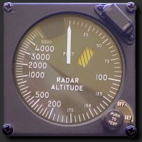
Figure 1: Radar- Altimeter display using a logarithmic scale

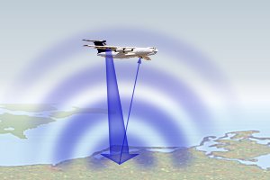
Figure 2: Principle of measurement
Altimeters
Altimeters are nadir-looking pulse-radars often. They transmit short microwave pulses and measure the round trip time delay t0 to targets to determine their distance (height h) from the air- or spaceborne sensor.
For lower height measurements a frequency modulated continuous wave radar (FMCW) can be used. This technology provides a better resolution but a lower maximum unambiguous height measurement at comparable wiring effort. Often both technologies are used simultaneously. For a pulse radar, the calculation of the height is possible according to the following approach:
| t0 = | 2·h | where: | t0 = delay time h = height above ground c0 = light speed |
(1) |
| c0 |
Reflection of an altimeter pulse from a flat surface
The transmitted pulse reaches the surface first on a small point. As the pulse advances, the illuminated area grows rapidly from a point to a disk, as does the returned power. The reflecting area depends on the beamwidth of the antenna. The energy from the center of the main beam has to travel the shorter path than the energy from the edges. An annulus is formed and the geometry is such that the annulus area remains constant as the diameter increases. The returned signal strength, which depends on the reflecting area, grows rapidly until the annulus is formed, remains constant until the growing annulus reaches the edge of the radar beam, where it starts to diminish.
Applications: used on
- aircraft for altitude determination and
- aircraft and satellites for topographic mapping,
- sea surface height measurements (from which wind speed can be estimated).
Examples given: TOPEX/Poseidon and Poseidon-2 Radar Altimeter on Jason-1 satellite.
