Comparative Reflectivity
Radar in recent years has become an important tool for the measurement of precipitation and the detection of hazardous weather conditions. Storms, hurricanes etc., develop by the transfer of heat energy from the ground or warm seas into the atmosphere. As warm moist air rises, the water vapour condenses to form cloud and releases the latent heat energy.
A storm can be regarded as a living entity; it grows, reaches a peak, then decays and fades away. It is not a stable object whitch moves with the wind. The weather radar therefore needs to scan the sky frequently enough to match the rate of change of the weather patterns.
For rainfall measurements an update rate of 15 minutes is sufficient and does not generate too vast a volume of data over 24 hour period, while for tracking hazardous conditions every 5 minutes is preferred.
Weather radar are required to detect and measure the rain intensity. They must be accurately calibrated and have a wide dynamic range (60 to 100 dBs or more) to cope with light rain at long-range and heavy rain near to the radar site. Radar echoes from weather phenomena are unlike those from aircraft, birds or surface clutter, whitch tend to be individual or group of echoes. Echoes from precipitation take the form of a very large number of scatters per unit volume and these particles can take on a variety of forms, including water droplets, ice crystals, hail, snow and mixtures of the above.
For this reason, and the variation in drop size distribution, ther is no fixed relationship between precipitation rate and the radar echo.
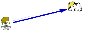
Case A |
This shows some light (non-precipitating cloud) from whitch the density of the returns will be relatively shallow. |
|
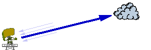
Case B |
This case depicts a cloud formation with some precipitation (perhaps light rain or drizzle for example). Considerably more echoes can be expected from precipitating weather than from non-precipitating weather. |
|
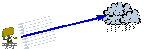
Case C |
This case shows heavy cloud with large quantities of rain held in it. This might be for example a heavy thunderstorm. The density of this formation will be very high and hence the returns will be quite intense (as shown). |
|
Table 1: comparison of the strength of the returns against the possible weather
Based upon experience and study, under specific transmission frequencies, a comparison chart may be developed to allow the comparison of the strength and reflectivity of the returns against the possible weather (or object) it is from.
One principle however that is important to note is that the „levels” of the return expected from different objects is more a rough guide (or best guess) than a precise definitive table.
High Level Weather Reflectivity Table
Notice: The level of reflectivity of the echo received from each type of weather is not shown in specific units as this will vary between transmission frequency and will most likely not be the same for any two radar sites!
Each weather radar station will hold a „look-up” table of reflections intensities which it can use to help to interpret and distinguish between different types of weather and objects based on the back-scattered echoes received at the antenna.
| Reflectivity | Weather / Object Type |
|---|---|
Most Reflective
|
Ground clutter |
Table 1: comparison of the reflectivity against the possible weather
All objects carry some degree of reflectivity; for weather, this varies by its intensity. Therefore, the level and power of echoes received back at the antenna can be interpreted to make an intelligent guess at the type and severity of a weather formation.
Tuning: It is stressed that the levels of reflectivity are rough estimates. Tuning of systems would often be carried out using other sensors (such as rain gauges or any other independent accurate source of weather data and parameters) to ensure optimum performance (this is done on a site by site basis!).
All types of weather and object provide some level of echoed returns. Clearly solid formations such as terrain in the line of sight or flying mechanical objects will provide the highest degree of returns.
This table breaks down comparative return types for precipitation only (clearly, there are other types of weather but these are not considered in this table).
Rainfall is most often measured using a relationship between the reflectivity factor (Z in mm6/m-3) and its precipitation intensity (R in mm / hr-1). Pre-defined reflectivity tables are held at a station and used as the basis for the initial interpretation and calculation.
The rainfall rate R can be empirically related to the reflectivity factor Z by the expression:
Z = aRb
where a and b are constants and R is the rainfall rate in mm/hr. The reflectivity factor Z
is dependent on the size and number of rain drops per unit volume of space and has the units of
mm6/m-3. Many researchers have produced a large variety
of values a and b. The value of a and b will be specific to each radar station configuration
(i.e. stored in a table). A Number of ambiguities are known and possible, depending on the radar
configuration and the particular meteorological situation.
| stratiform rain | Z = 200·R1.6 |
| orographic rain | Z = 31·R1.71 |
| thunder storms | Z = 286·R1.37 |
| snow | Z = 2000·R2 |
Table 2: Typical expressions for types of precipitation
There are other forms of identifiable weather which could be interpolated by weather radar
systems (although, depending on the frequency spectrum of the system, the type of equipment used,
its operational goals and the software of the station, not all of these might be available.
The types of information might cover;
- Rainfall (or storm intensity), further classified in terms of its precipiation intensity against echo intensity. Rainfall is commonly classified into 6 bands (light, moderate, heavy, very heavy, intense and extreme). Rainfall rates will be quite different between stratiform cloud and convective cloud formations. The FAA, for example, have issued a classification scale as an information circular.
- Non-precipiating clouds (liquid or ice)
- Fog and feezing fog - sometimes also providing a figure for the estimated visibility.
- Clear-air-turbulence (only with certain spectrums - most effective systems whitch can identify clear-air-turbulence operate in the L-band!)
In the absence of further information it is generally acceptance, in mid-latitude temperature climates, to use a default value of Z = 200R1.6. Usually Z is specified in a logarithmic scale where ZdB = 10 log Z.