Rain Attenuation
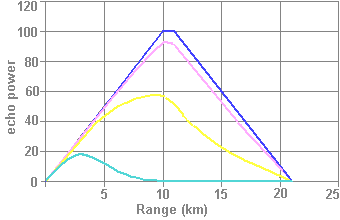
Figure 1: Rain attenuation
Rain Attenuation
This graphic shows the effect that the rain attenuation has a different value at different wavelengths.
The top (blue) curve shows the unattenuated weather; a storm 20 km in diameter with rainfall rising to 100 mm/hr in the centre. The next (mauve) curva shows the returns as seen by an S- Band radar. The next two curves (yellow and light blue) show the outputs from an C- Band and an X- Band radar. All the results have been normalised.
It is obvious that X- Band suffers from attenuation and cannot see far into a severe storm, while S- Band has little attenuation. C- Band offers a good compromise. For these reasons, X band weather radars are only used for short ranges, S band radars are used in the tropics because they can see beyond a severe storm, and C- Band is favoured in temperate latitudes, having good sensitivity and range.