Radar Siting
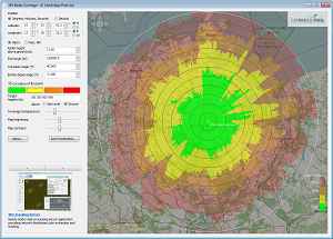
Figure 1: Screenshot of a free radar siting program of Cambridge Pixel Ltd., here showing the e.g. location of the ASR 910 in Neubrandenburg-Trollenhagen (Germany).
Figure 1: Screenshot of a free radar siting program of Cambridge Pixel Ltd., here showing the e.g. location of the ASR-910 in Neubrandenburg-Trollenhagen (Germany).
Radar Siting
Radar Siting are all measures for achieving optimal results with respect to the desired performance of the radar, built at a given site. It is mainly the interpretation of the effects of the phenomena of the Earth’s curvature and especially line-of-sight obstructions caused by the terrain. But it includes also the effects of refraction from electromagnetic waves by the atmosphere.
In the past, these calculations were determined by extensive terrain surveying using a theodolite. It was measured the terrain angle (the average gradient of the ground) and the coverage angle (angle between the radar antenna and the horizon) around the radars site. Today may be used electronic map data and the computing power of modern computers. It can be simulated the evaluation of a site for a possible radar position. Basic programs use only the coverage angle of the terrain (as shown in Figure 1 and Figure 2). They show the radar coverage for given flight altitudes regardless of the frequency range and possible reflections on the ground and its interferences. These results are usable for very high frequencies for an initial site selection or a choice for an antennas height, generally without problems.
More complicated programs take into account in, addition, the energetic maximum radar range (see radar range equation), any necessary probability of detection, parasitic reflection from the floor and its interferences, and possible anomalous wave propagation (e.g ducting). However, such a program is very expensive and requires precise manual input of the required environment variables and the parameters of the given radar.
Bildergalerie
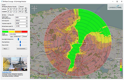
Figure 2: Radar coverage of a maritime radar located in Kiel harbor. (Screenshots made with courtesy of Cambridge Pixel Ltd.)